Canadian Geography - Canada FAQ
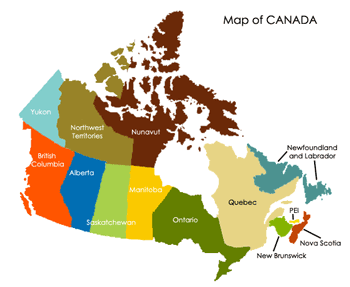
Canada consists of ten provinces: Prince Edward Island, Alberta, Manitoba, British Columbia, New Brunswick, Nova Scotia, Newfoundland and Labrador, Quebec, Ontario, and Saskatchewan, as well as of and three territories: Northwest Territories, Nunavut, and Yukon. Over 70 percent of the population is concentrated close to the border with the United States. The key difference between provinces and territories is that the latter derive authority from the federal government, whereas the former derive powers straight from the Constitution of Canada.
 Among the large cities in Canada are Toronto, Montreal, Edmonton, Calgary, Winnipeg, Vancouver, Ottawa. Toronto is the capital of Ontario and the biggest city in Canada. Populated by more than 2.5 million residents (4.7 million in the GTA), it is the fifth largest municipality on the territory of North America. Toronto is the economic capital of the country and a global financial center. The key economic sectors in Toronto include telecommunications, finance, business services, software production, tourism, aerospace, medical research, and education, among others. Montreal, the second largest city, is situated in Quebec and has a population of more than 1.9 million residents. Montreal is a major center of finance, technology, commerce, pharmaceutical production, tourism, and culture. The capital of Alberta, Edmonton, is inhabited by more than 730 thousand residents and is the second most densely populated provincial capital on the territory of Canada. The city is a governmental, cultural, and educational center, known as ‘the Festival City’.
 The country’s topography is quite diverse, mostly due to its large territory. Canada covers vast maritime land and boasts the longest coastline in the world – 202,080 km. The Pacific border is frayed with fjords and channels. The northern regions, close to the Arctic, are covered with ice, which is also a characteristic feature of the Rocky Mountains. Most of the country is covered with Boreal forests (a.k.a Taiga), save the flat Canadian Prairies in the southwest, where the climate fosters the agriculture industry and a great number of grain farms can be found. The most densely populated areas are located in the St. Lawrence plain (the provinces of Ontario and Quebec), close to the Great Lakes. These lands are part of the so-called Canadian Shield, a rock base encompassing Saskatchewan, Manitoba, Ontario, Quebec, some parts of Newfoundland and Labrador. Canada’s population is rather small for its size, only 34 million people inhabit the territory, in contrast to around 145 million in Russia. A large part of the territory is still wilderness. The Rocky Mountains cover a major segment in the west. Most mountains in Canada are found in British Columbia, Alberta and the Yukon Territory. The highest point is in the Yukon - Mount Logan (6050m). There are more lakes in Canada than anywhere else: 561 lakes with a surface larger than 100 sq.km. Therefore, the country holds most of the fresh water in the world. The major river systems are Mackenzie and the St. Lawrence, the latter being navigable for over 3000 km.
What is the capital of Canada?
What are the capitals of the Canadian provinces and territories?
How big is Canada?
What is the largest city in Canada?
What is the longest river in Canada?
What is the highest point in Canada?
What countries does Canada have borders with?
What is the population of Canada?
In which part of Canada do most Canadians live?
What ethnic groups does Canada have?
How much of the world’s fresh water is in Canada?
What are the biggest lakes in Canada?
What part of Canada is covered with forests?
How many geographical regions does Canada have?
Canada is part of what continent?
How many time zones are there in Canada?
Canadian Rockies
Top 10 Places to Visit in Canada
Top 5 Winter Vacation Destinations in Canada
Top 10 Places to Visit in Toronto
The Canadian Prairies: Ecozone and Wildlife Diversity
The Canadian Shield: Mining Towns and Wildlife Habitats